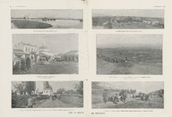
Manastır güzergahında. İmparatorluğun varoluş tablosu - On the route of Monastir. Graph of an imperial existence.
| DC Field | Value | Language |
|---|---|---|
| dc.provenance | Feridun Fazıl Tülbentçi Arşivi - Feridun Fazıl Tülbentçi Archive | |
| dc.contributor | Choublier. | |
| dc.creator | Lucien Naas. | |
| dc.date.accessioned | 2018-09-08T17:11:17Z | - |
| dc.date.available | 2018-09-08T17:11:17Z | - |
| dc.date.issued | 1916-11-25 | |
| dc.identifier | FFTDOC01298 | |
| dc.identifier.other | 100403 | |
| dc.identifier.uri | https://archives.saltresearch.org/handle/123456789/26955 | - |
| dc.description | Kenali'nin güneyindeki ovalarda sulu yol. Manastır ana meydanının köşesi. Petorak karşı saldırılarının ortasında, Fransız ve Bulgar topçu ateşi altında kalan Verbeni Köyü. Geri çekilen Bulgarlar tarafından kesilen Manastır güzergahı. Güney-Batı yüksekliklerinden görünen Manastır şehri: Ufukta, Prilep Dağları. Fransız sınırları boyunca kaçan Manastır'ın güney köylerinde oturanlar, arka tarafa yönlendirildi. Çizginin altındaki veya üzerindeki 68 sayıları İmparator Franz-Yusuf'un egemenlik yıllarını temsil ediyor - A flooded route in the plains south of Kenali. A corner of the main square of Monastir. The village of Verbeni, which was under the fire of French and Bulgarian artillery, in the midst of attacks against Petorak. The route of Monastir cut off by the Bulgarians retreating. The city of Monastir seen from the heights of the South-West: On the horizon, the Prilep mountains. The inhabitants of the villages in the south of Monastir fleeing through French lines and directed toward the back. The 68 numbers written above or below the drawing are those of the successive years of the reign of Emperor Franz-Joseph. | |
| dc.format | 30,2-41 cm | |
| dc.format | Printed | |
| dc.language | Fransızca - French | |
| dc.rights | Open Access | |
| dc.source | L'illustration, no. 3847, p. 494-497 | |
| dc.title | Manastır güzergahında. İmparatorluğun varoluş tablosu - On the route of Monastir. Graph of an imperial existence. | |
| dc.type | Kupür - Clipping | |
| dc.note | Manastır'ın güzergahında çekilen fotoğraflar. Bir tablo Avusturya-Macer imparatorluk tarihi, Franz-Yusuf'la 1848'den beri. - A series of photos taken on the route to Monastir, Tunisia. A graphic/chart detailing the Austro-Hungarian imperial history starting in 1848 with Franz-Joseph. | |
| dc.location | SALT Research | |
| dc.catalogedby | Christin Zurbach | |
| dc.date.cataloged | 2013-06-19 | |
| dc.date.acquisition | 2007-12-13 | |
| dc.format.numberofscans | 2 | |
| dc.format.numberofpages | 3 | |
| dcterms.accrualMethod | Purchase | |
| Collections | Clippings and Documents | |
Files
| File | Description | Size | Format | |
|---|---|---|---|---|
| FFTDOC01298.jpg | 6.8 MB | JPEG | ||
| FFTDOC01298A1.jpg | 4.25 MB | JPEG |


