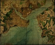
Plan de Constantinople. Service Topographique des Armées Alliées d'Occupation.
| Dublin Core Alanı | Değer | Dil |
|---|---|---|
| dc.date.accessioned | 2018-09-22T23:20:03Z | - |
| dc.date.available | 2018-09-22T23:20:03Z | - |
| dc.date.issued | 1922-07 | |
| dc.identifier | APLCOF02 | |
| dc.identifier.uri | https://archives.saltresearch.org/handle/123456789/113058 | - |
| dc.format | 41-50 cm | |
| dc.language | Fransızca - French | |
| dc.rights | Local Access | |
| dc.title | Plan de Constantinople. Service Topographique des Armées Alliées d'Occupation. | |
| dc.type | Harita - Map | |
| dc.location | Edhem Eldem Koleksiyonu | |
| dc.catalogedby | HILALA | |
| dc.date.cataloged | 15.06.2004 | |
| dc.date.acquisition | 17.05.2004 | |
| dc.format.numberofscans | 1 | |
| dc.format.numberofpages | 1 | |
| dcterms.accrualMethod | Courtesy of | |
| dc.rights.holder | Consommer l'Orient | |
| Koleksiyonlar | Service Topographique du C.O.F.C. | |
Dosyalar
| Dosya | Tanım | Boyut | Biçim | |
|---|---|---|---|---|
| APLCOF02.jpg | 1.64 MB | JPEG |


