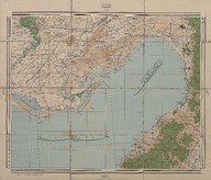
Adana haritası (1:200000) - Map of Adana (Scale 1:200000)
| DC Field | Value | Language |
|---|---|---|
| dc.date.accessioned | 2018-09-22T11:26:52Z | - |
| dc.date.available | 2018-09-22T11:26:52Z | - |
| dc.date.issued | 1917 | |
| dc.date.issued | 1918 | |
| dc.identifier | APLEH091 | |
| dc.identifier.other | 108101 | |
| dc.identifier.uri | https://archives.saltresearch.org/handle/123456789/107005 | - |
| dc.description | Misis, Kilis, Antalya, Mersin | |
| dc.format | 57,5-48,5 cm | |
| dc.format | Baskı-Renkli - Printing-Colored | |
| dc.language | Osmanlı Türkçesi - Ottoman Turkish | |
| dc.publisher | Erkân-ı Harbiye-i Umûmiye | |
| dc.rights | Open Access | |
| dc.title | Adana haritası (1:200000) - Map of Adana (Scale 1:200000) | |
| dc.type | Harita - Map | |
| dc.note | Sene-i maliye: 1333 | |
| dc.location | SALT Research | |
| dc.catalogedby | Sinem Gülmez | |
| dc.date.cataloged | 2013-01-02 | |
| dc.format.numberofscans | 1 | |
| dc.format.numberofpages | 1 | |
| dcterms.accrualMethod | Satın alma - Purchase | |
| Collections | Erkan-ı Harbiye | |
Files
| File | Description | Size | Format | |
|---|---|---|---|---|
| APLEH091.jpg | 6.43 MB | JPEG |


